1. Beverly Hills Quadrangle.
2. The adjacent quadrangles are Canoga Park, Van Nuys, Burbank, Topanga, Venice, Inglewood.
3. It was created in 1995.
4. The North American datum was collected in 1927. The National Geodetic datum was collected from 1929. Datum collected by the USGS consists of planimetery imagery(1978) and photoinspected imagery(1995).
5. 1:24,000
6. a) 1200m
b) 1.89 mi
c) 2.64 in
d) 12.5 cm
7. The contour interval is 20 feet.
8. a) Public Affairs Building- 34o 4’27”, 118o 26’15”; 34.07416666666667, 118.4375
c) Upper Franklin Canyon Reservoir- 118o 24’15”, 34o 7’15”; 118.40416666666667, 34.12083333333334
9. a) Greystone Mansion (560-580ft; 170-177m)
b) Woodlawn Cemetery (140ft; 42.6m)
c) Crestwood Hills Park (600-700ft;183-213m )
10. UTM zone: 11
11. 361472.2745076031, 3763170.113931325
12. 1000x1000= 1000000 sq. mi
13.
14. 14o
15. North to South
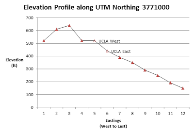
16. UCLA


No comments:
Post a Comment